AXYS Technologies (AXYS) is undertaking a metocean data collection campaign (Humboldt Project) off the West Coast of the United States, Humboldt, in Northern California.
Purpose of the Project
The project is designed to capture valuable information about atmospheric, meteorological, and environmental conditions near the Humboldt Wind Energy Area (WEA). This information will be used by researchers, engineers, and potential wind energy developers to understand and characterize the site and create some useful pre-development baselines.
Some of the data that will be measured as part of the project include:
- Wind speeds, direction and turbulence intensity at various heights above sea level
- Wave measurements and current profiling throughout the water column to the seabed
- Water characteristics – salinity, temperature, etc.
- Near surface atmosphere characteristics – temperature, barometric pressure, humidity, precipitation
- Environmental monitoring for marine mammals, fish, and avian species
- Real-time surface weather data
Some of these data sets will be shared with AXYS research collaboration partners for collaborative analysis, and other data sets will be used by our data subscribers. AXYS will also maintain a Humboldt project website with publicly available surface weather data for fisheries and mariners. Further information is provided in the Ongoing Communication section below.
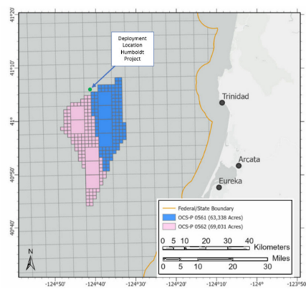
Location of the Sites
Figure 1 provides an overview of the location of the Humboldt Project in the context of nearby offshore wind lease areas managed by the Bureau of Ocean Energy Management (BOEM). The project includes two equipment systems installed near the Northern boundary of the current Offshore Wind lease area and the possibility of a third as a swap-out system for secondary data collection.
Nature of the Installation
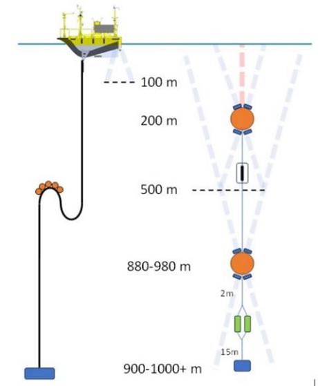
The deployed equipment consists of a Floating Lidar System and a taught mooring subsea system deployed about 2000m apart. The Floating Lidar System is mounted on an AXYS FLiDAR WindSentinel 6m buoy with buoy-mounted meteorological, oceanographic, and environmental sensors and communications, power, and surveillance equipment. The subsea system consists of a series of current and mammal monitoring sensors to capture the full water column currents and temperature profile and detect and identify nearby marine mammals by their acoustic signals, with an upper float at 200m below the surface.
The Floating LIDAR System buoy will be located at WGS84 41° 05’ 47.4’’ N, 124° 41’ 17.2’’ W, about 24 nautical miles west of Trinidad, CA, in approximately 1000 m of water. The Floating LIDAR System is equipped with a navigation light, radar reflector and AIS. Its swinging radius will be approximately 1,800 meters.
The subsurface current profiler system will be located at WGS84 41° 06’ 15.8’’ N, 124° 40’ 00.1’’ W on a taut mooring with no surface presence and a clearance depth of 200 m over the upper float. The deployed systems will be listed in the USCG Light List, Notice to Mariners, and updated charts upon deployment.
Commitment to Safety and the Environment
A prime objective of this measurement campaign is to collect data safely, efficiently, and with minimal environmental impact. The FLiDAR system’s primary power sources are renewable, and the system is designed to be deployed for long periods with minimal intervention, limiting the impact of vessel emissions. Our mooring systems are designed to be secure even in extreme weather and are designed to be recovered at the end of the deployment. AXYS operations are conducted safely and with consideration for marine mammals and fish. Support vessels will utilize the crabber/towboat lane when deploying or servicing the system.
environmental commitment also extends to using the data and our efforts to reach out to academic and NGO research communities to find collaborators to get insights from the data sets collected. The site characterizations will support informed future development in the WEA.
Advisories
Mariners should exercise caution to avoid anchoring or trawling in the deployment location of the metocean subsea equipment & FLiDAR buoy. Trawling in the immediate area of the deployed systems and serious interference with these systems may damage fishing gear and our systems/moorings. In the event of any vessel fouling a mooring, every effort should be made to clear the anchor or gear by normal methods. Should these efforts fail, the anchor or gear should be slipped and abandoned without attempting to cut the mooring.
Vessels shall keep a safe distance from the FLiDAR/Moorings to avoid interference. Vessels, especially those engaged in trawling or other subsurface activity, should maintain a safe distance from the deployed systems. In all cases, Mariners should contact AXYS if there is any entanglement.
Timing and Ongoing Communication
The FLiDAR and Metocean data collection equipment will be on-site from March 2024 through March 2026.
AXYS will maintain a Humboldt project website that will provide ongoing information and updates about the project and real-time surface winds, waves, and temperature data useful to fisheries, marine operations and safety. This site can be found at (URL HERE). Data will also be served via the Central and Northern California Observing System (CENCOOS) data portal and other regional ocean data and model products at cencoos.org.
General questions/inquiries: humboldt@axys.com
Fisheries, Regulators and Research Initiatives inquiries: Doug Wilson, Research and Stakeholder Liaison, Email: dwilson@axys.com
Emergencies: flidar@axys.com
Press Inquiries: press@axys.com