AXYS – APS
Analytics Portal Service
A robust and secure web-based portal for controlling a network of systems and sensors.
About the AXYS-APS:
The AXYS-APS (Analytics Portal Service) allows users to visualize and integrate collections of different data types across space, time, parameter, and other dimensions, which will result in increased utilization of data for improved resource management, planning and research efforts.
AXYS-APS is a robust and secure web-based portal for controlling a network of systems and sensors, as well as collecting, managing, analyzing, visualizing and disseminating environmental and oceanographic data from AXYS sensor platforms and a variety of other sources.
Workspace Collaboration Portal
- Improved communication, collaboration & data sharing
- Reduced duplication of files
- Reduced data management cost
- Improved data security
- Secure sign-on & project/data access controls
- Advanced file/document management & administration tools
- Enables data sharing across disparate teams
- Process historian tracks team activities
Secure Cloud-based GeoPortal
- Access data, reports & graphs in real-time
- Control/configure systems & sensors remotely
- Perform data/predictive analytics
- Reduced data management costs Improved access to data for quicker, fact-based decisions
- Improved visibility and control of sensors & data collection
- Improved communication, collaboration & data sharing
- Automated decision support tools
AXYS-APS Features:

Real time access to remotely sensed data

Configure sensors, telemetry & power systems remotely
Redundant data storage

Real-time performance monitoring & alerts
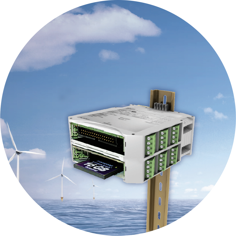
WatchMan500™ Core Technology
Low power, reliable data collection, storage & distribution solution for remote sensor applications & networks.
WatchMan500™ Features:
Modular form factor & interface
Designed for long-term operations in remote & harsh environments
Remote configuration & diagnostics
Configurable sensor interface
The WatchMan500™ node is an intelligent, configurable and expandable sensor I/O controller and data logger with two-way communications, designed for long-term operations in any location or environment. This platform is the ideal solution for any application requiring data collection, control, processing, or remote system management. It can interface with custom or off-the-shelf sensor equipment, software and telemetry.
The unique infrastructure of the WatchMan500TM node allows additional I/O to be added by interconnecting multiple modules. Any one of these modules can be designated the “primary module” and enables the system to be remotely queried and configured. This primary module processes then forwards the data over a chosen communication link to a pre-designated data center. Open architecture enables the WatchMan500 to accept virtually any sensor or telemetry. Expandability to up to 28 modules allows hundreds of potential sensors to be connected to one system in a single NEMA 4 enclosure with a single communications link and power source.
Moorings
AXYS has installed moorings to depths up to 5000 meters and follows the industry’s highest design standards.
Mooring types:
Moorings can be modified to address key criteria:
- Surface Moorings
- Sub-Surface Moorings
- Custom Moorings
- TRIAXYS Wave Buoy Moorings
Moorings can be modified to address key criteria:
- Size and shape of excursion
- Seabed floor considerations
- Ease of deployment and recovery
The mooring design will take the following factors into consideration:
- Water depth
- Type of deployment vessel and equipment available on board
- Desired length of life of the mooring
- Vessel traffic in the vicinity of the mooring
- Current speed
- Tides
- Waves
- Winds
- Typhoons
AXYS in-house mooring design experts have extensive experience with mooring operational buoys.
AXYS provides a computer designed and dynamic load-tested mooring that will provide maximum reliability and long-term performance.
All mooring designs are analyzed with numerical models and modeled with dynamic simulation software that confirms their operational performance. These mathematical techniques, sound engineering practices, and years of experience to select the best mooring materials, result in long-life, reliable moorings. Our designs have been proven in very aggressive environments across the world, and consideration is specifically given to the durability of the mooring within a range of environmental challenges.
Commissioning & Deployment
The commissioning service consists of assembling and configuring the system once it has arrived at its destination.
AXYS Technicians work with the local team to ensure the equipment is fully functional and meets their operational requirements. Once the system has been commissioned, it is then ready for deployment or installation. Commissioning of a buoy typically includes: reassembly of the system, testing of the reassembled system to ensure compliance with factory standards, and preparation for deployment.
AXYS field technicians deploy buoys and install land stations in many different environments around the world. AXYS advises clients on the logistics requirements, such as vessels, cranes, forklifts, and work sites, depending on the type of system being deployed or installed. Field technicians will work with local personnel to carry out the tasks necessary to ensure the system is operating to specifications and they can provide guidance to the vessel crew to ensure it is safely deployed. Deployment of a buoy typically involves transport of the system to its operating location, deployment of the mooring, and final deployment check of the system once installed.
AXYS system arrives at destination
Reassembly of the AXYS system
AXYS Technicians work with local team
Final deployment check of system
Repair & Calibration
The AXYS Service Team employs senior field technicians that understand AXYS systems intimately and have over 60 years of combined oceanographic and operational experience.
These technicians are capable of board level diagnostics/repair in the field, and individual electronic component level diagnostics/repair in the lab.AXYS can coordinate the logistics required to service or repair systems, and can also provide annual service contracts to help mitigate any downtime due to system wear over time. Depending on the nature of the work, service can be performed in the field or at our manufacturing facility.
Remote Technical Support:
The Customer Service department can provide remote technical support for clients (phone, email and system remote access). Depending on the telemetry used, an AXYS technician may have remote access to a system to diagnose, troubleshoot, and change configuration from our corporate office. Where telemetry does not permit remote access, other options exist to access a deployed system with the help of customers. , (i.e. TCP connection to a customer DMS installation).
Calibration:
The AXYS service and production laboratory is located in Sidney, B.C. Canada and is certified by the National Research Council of Canada to provide wave instrument calibration for government run/regulated programs.
Request Support:
We’d love to hear what your needs are, and how our environmental monitoring systems and solutions, may contribute to your success.
Please take the time to fill out our form below and we will contact you promptly.
Telemetry
AXYS offers many telemetry options for monitoring and collecting remote environmental data.
Data can be sent in virtual real time and clients are able to specify their preferred telemetry option.Satellite
Iridium
Iridium Satellite uses a dedicated constellation of 66 low-earth orbiting (LEO) operational satellites and 14 in-orbit spares positioned at a height of approximately 780km. The satellites orbit from pole to pole with an orbit of roughly 100 minutes. Short burst data packets are transmitted to the nearest satellite and received by a gateway on earth, either directly or via another satellite in the network, and delivered to the DMS software in email format. Iridium’s two-way service avoids multiple redundant transmissions by acknowledging that data has been sent. This system is best suited to situations where large amounts of data need to be transmitted, as airtime is charged by the minute.
Inmarsat
Inmarsat is a high orbit geostationary satellite telemetry system operating in a ±60° latitude. The Inmarsat system consists of four communications satellites backed up by an additional five satellites that can be brought into use in the event of technical difficulties or high traffic. There are a number of different bandwidth telemetry services available through Inmarsat.
IsatData Pro offers a higher bandwidth than the Isat M2M service, with 10Kb upload and 6Kb download. Isat M2M is used for low bandwidth messaging and platform position monitoring. Both IsatData Pro and Isat M2M are capable of providing alerts along with regular data transmissions, and can be either pre-programmed or remotely triggered to send automatic messages. This transmitted data is archived on a database and available for secure client access.
ARGOS
The Argos (Advanced Research and Global Observation Satellite) system is comprised of low orbit, non-geostationary satellites. Argos satellite telemetry is a limited data communications solution for use in remote locations where VHF or cellular telemetry are intermittent or unfeasible. This telemetry option is controlled through NOAA and there are some restrictions to applications and users; users need to apply for the service.
GOES
GOES (Geostationary Operational Environmental Satellite) is a geostationary satellite system that provides 24-hour coverage and is generally used by governments and institutions. Interested persons must apply for its use, as there is limited access to this system.
ORBCOMM
The ORBCOMM (Low-Earth Orbit Satellite) system uses a network of low-Earth, near-polar orbital satellites for data and messaging communications services. ORBCOMM provides tracking, monitoring, and messaging capabilities to and from anywhere in the world, and there are no restrictions to applications or users.
Cellular
HSPA Cellular (compatible with GPRS)
Cellular telemetry offers high bandwidth, two way communications for deployments within coverage areas. AXYS clients are required to subscribe to a data plan with a local service provider. The two way telemetry is a preferred choice for near-shore deployments.
VHF/UHF
Radio telemetry is one of the most common methods of transmitting data from remote inaccessible installations, (water or land). Radio telemetry requires a clear line-of-sight between the monitoring system and the base station for distances up to 30 km. While antenna positioning, gain, tuning, and ambient noise can adversely affect range, our systems can be configured to send multiple transmissions to ensure a consistently high data throughput.
Data Logging
Internal Data Logging
AXYS products include an internal data logging option. This can be used as either a backup system in the event of marginal telemetry conditions or as a stand-alone feature. Data sampled by the system is logged onto a large capacity Compact Flash (CF) Card.
